


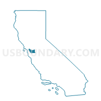
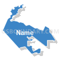
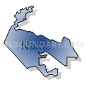
Voting District 20585, Alameda County, California
About
Outline

Summary
| Unique Area Identifier | 528860 |
| Name | Voting District 20585 |
| County | Alameda County |
| State | California |
| Area (square miles) | 6.46 |
| Land Area (square miles) | 6.46 |
| Water Area (square miles) | 0.00 |
| % of Land Area | 100.00 |
| % of Water Area | 0.00 |
| Latitude of the Internal Point | 37.65282720 |
| Longtitude of the Internal Point | -122.05312840 |
Maps


Graphs
Select a template below for downloading or customizing gragh for Voting District 20585, Alameda County, California


Neighbors
Neighoring Voting District (by Name) Neighboring Voting District on the Map
- Voting District 20525, Alameda County, CA
- Voting District 20565, Alameda County, CA
- Voting District 20575, Alameda County, CA
- Voting District 20580, Alameda County, CA
- Voting District 20590, Alameda County, CA
- Voting District 20605, Alameda County, CA
- Voting District 20620, Alameda County, CA
- Voting District 20740, Alameda County, CA
- Voting District 20745, Alameda County, CA
- Voting District 20750, Alameda County, CA
- Voting District 20755, Alameda County, CA
- Voting District 41375, Alameda County, CA
- Voting District 41385, Alameda County, CA
- Voting District 41390, Alameda County, CA
- Voting District 41395, Alameda County, CA
Top 10 Neighboring County Subdivision (by Population) Neighboring County Subdivision on the Map
Top 10 Neighboring Place (by Population) Neighboring Place on the Map
Top 10 Neighboring Unified School District (by Population) Neighboring Unified School District on the Map
Top 10 Neighboring State Legislative District Lower Chamber (by Population) Neighboring State Legislative District Lower Chamber on the Map
Top 10 Neighboring State Legislative District Upper Chamber (by Population) Neighboring State Legislative District Upper Chamber on the Map
Top 10 Neighboring 111th Congressional District (by Population) Neighboring 111th Congressional District on the Map
Top 10 Neighboring Census Tract (by Population) Neighboring Census Tract on the Map
- Census Tract 4381, Alameda County, CA (7,675)
- Census Tract 4363, Alameda County, CA (7,129)
- Census Tract 4364.01, Alameda County, CA (7,042)
- Census Tract 4351.03, Alameda County, CA (6,403)
- Census Tract 4366.01, Alameda County, CA (6,091)
- Census Tract 4312, Alameda County, CA (5,627)
- Census Tract 4382.04, Alameda County, CA (5,368)
- Census Tract 4351.04, Alameda County, CA (5,216)
- Census Tract 4351.02, Alameda County, CA (5,179)
- Census Tract 4378, Alameda County, CA (4,621)